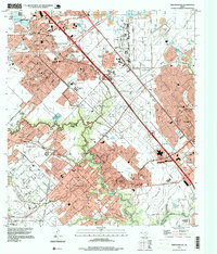
1995 Map of Friendswood
USGS Topo · Published 1999About this map
Friendswood Oil Field and the sprawling military installation at Ellington Field anchor this mid-1990s look at the rapid suburbanization south of Houston. The landscape is a complex intersection of industry and infrastructure, where numerous oil wells and the tracks of the Atchison Topeka and Santa Fe railroad meet the burgeoning residential developments of Pearland, Friendswood, and Clear Lake City. Commercial hubs like Almeda Mall and Baybrook Mall follow the corridor of the Gulf Freeway, illustrating the late-century transition from oil-patch economy to regional retail and services.
Find a feature on this map
51 named features on this map. Tap any name to fly to it.
Don’t see what you’re looking for? This feature index may not catch every label — zoom into the map to look around manually.
Map Details
Editions of this 1995 Friendswood Map
This is the sole edition of this map. No revisions or reprints were ever made.
Other maps of this area

1915 · Park Place
USGS Topo · 1:24,000

1915 · Deepwater
USGS Topo · 1:24,000

1916 · Genoa
USGS Topo · 1:24,000

1916 · Seabrook
USGS Topo · 1:24,000

1916 · La Porte
USGS Topo · 1:24,000

1919 · Deepwater
USGS Topo · 1:31,680

1920 · Seabrook
USGS Topo · 1:31,680

1920 · Genoa
USGS Topo · 1:31,680

1920 · Mykawa
USGS Topo · 1:31,680

1920 · La Porte
USGS Topo · 1:31,680