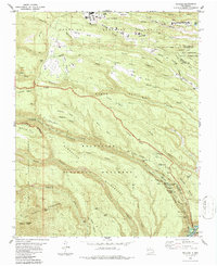
1984 Map of Frijoles
USGS Topo · Published 1987About this map
Bandelier National Monument defines this landscape of deep-cut canyons and high mesas, preserving an intricate network of Ancestral Puebloan sites. The topography reveals a concentrated area of pre-colonial settlement along the Rito de los Frijoles, including the circular Tyuonyi Ruin and nearby Frijolito Ruins. Higher on the mesas, cultural landmarks like the Stone Lions Shrine and Yapashi Ruins are connected by an extensive system of pack trails that traverse the Bandelier Wilderness. To the north, the modern infrastructure of Los Alamos and the San Ildefonso Indian Reservation meet at the edges of Sandia Canyon and Mortandad Canyon. The southern extent of the map tracks the descent toward the Rio Grande and the Cochiti Reservoir, passing the dramatic drops of Upper Frijoles Falls and Lower Frijoles Falls near Boundary Peak.
Find a feature on this map
69 named features on this map. Tap any name to fly to it.
Don’t see what you’re looking for? This feature index may not catch every label — zoom into the map to look around manually.
Map Details
Editions of this 1984 Frijoles Map
Other maps of this area

1892 · Santa Clara
USGS Topo · 1:125,000

1952 · White Rock
USGS Topo · 1:24,000

1952 · Valle Toledo
USGS Topo · 1:24,000

1952 · Frijoles
USGS Topo · 1:24,000

1952 · Puye
USGS Topo · 1:24,000

1952 · Montoso Peak
USGS Topo · 1:24,000

1952 · Guaje Mountain
USGS Topo · 1:24,000

1953 · Cochiti Dam
USGS Topo · 1:24,000

1953 · Bland
USGS Topo · 1:24,000

1953 · Canada
USGS Topo · 1:24,000