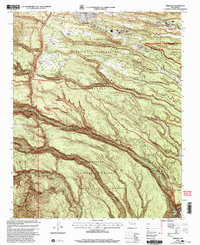
2002 Map of Frijoles
USGS Topo · Published 2003About this map
Los Alamos National Laboratory occupies the northern half of this landscape, where the Pajarito Plateau is deeply incised by narrow canyons. The high mesas, such as Twomile Mesa and Pajarito Mesa, are separated by drainage systems like Mortandad Canyon and Potrillo Canyon, revealing the complex administrative and scientific footprint of the Department of Energy at the turn of the 21st century. Infrastructure including a Communication Tower, Substation, and numerous Sewage Disposal Ponds are mapped alongside the natural terrain.
Find a feature on this map
44 named features on this map. Tap any name to fly to it.
Don’t see what you’re looking for? This feature index may not catch every label — zoom into the map to look around manually.
Map Details
Editions of this 2002 Frijoles Map
This is the sole edition of this map. No revisions or reprints were ever made.
Other maps of this area

1892 · Santa Clara
USGS Topo · 1:125,000

1952 · White Rock
USGS Topo · 1:24,000

1952 · Valle Toledo
USGS Topo · 1:24,000

1952 · Frijoles
USGS Topo · 1:24,000

1952 · Puye
USGS Topo · 1:24,000

1952 · Montoso Peak
USGS Topo · 1:24,000

1952 · Guaje Mountain
USGS Topo · 1:24,000

1953 · Cochiti Dam
USGS Topo · 1:24,000

1953 · Bland
USGS Topo · 1:24,000

1953 · Canada
USGS Topo · 1:24,000