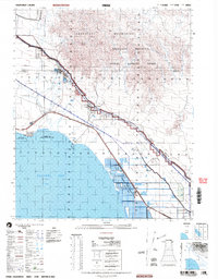
2002 Map of Frink
USGS Topo · Published 2004About this map
Chocolate Mountains rise sharply above the desert floor, defining the eastern horizon of this Imperial Valley landscape. This territory at the turn of the 21st century highlights the industrial and recreational utility of the California desert, where the vast Salton Sea meets structured irrigation and military land use. The Southern Pacific line runs parallel to the shoreline, connecting the settlement at Bombay Beach with the historic rail point of Frink. To the south, the Imperial State Wildlife Area (Wister Unit) and several salt evaporators mark the managed wetlands near Wister. The upland areas are dominated by the Aerial Gunnery Range and a Military Reservation, reflecting the region's long-standing role in defense training. This map preserves the 2002 shoreline and the network of canals and levees that support the low-lying East Mesa.
Find a feature on this map
18 named features on this map. Tap any name to fly to it.
Don’t see what you’re looking for? This feature index may not catch every label — zoom into the map to look around manually.
Map Details
Editions of this 2002 Frink Map
This is the sole edition of this map. No revisions or reprints were ever made.
Other maps of this area

1940 · Kane Spring
USGS Topo · 1:62,500

1940 · Iris
USGS Topo · 1:62,500

1940 · Frink
USGS Topo · 1:62,500

1940 · Cottonwood Spring
USGS Topo · 1:62,500

1940 · Iris Pass
USGS Topo · 1:62,500

1940 · Canyon Spring
USGS Topo · 1:62,500

1940 · Durmid
USGS Topo · 1:62,500

1943 · Canyon Spring
USGS Topo · 1:62,500

1944 · Cottonwood Spring
USGS Topo · 1:62,500

1944 · Durmid
USGS Topo · 1:62,500