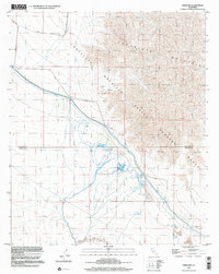
1998 Map of Frink NW
USGS Topo · Published 2002About this map
The Chocolate Mountains dominate the eastern landscape of this desert sheet, their eastern slopes designated as a military Aerial Gunnery Range. Along the valley floor, the Coachella Canal cuts a sharp line through the arid terrain, supported by a network of Siphons and protective Levees that manage the flow of water across this low-lying basin. The map reveals a specific desert economy centered on recreation and resource extraction, notably the Hot Mineral Spa and several Mobile Home Parks that cluster near the water infrastructure.
Find a feature on this map
18 named features on this map. Tap any name to fly to it.
Don’t see what you’re looking for? This feature index may not catch every label — zoom into the map to look around manually.
Map Details
Editions of this 1998 Frink NW Map
This is the sole edition of this map. No revisions or reprints were ever made.
Other maps of this area

1940 · Frink
USGS Topo · 1:62,500

1940 · Cottonwood Spring
USGS Topo · 1:62,500

1940 · Canyon Spring
USGS Topo · 1:62,500

1940 · Durmid
USGS Topo · 1:62,500

1943 · Canyon Spring
USGS Topo · 1:62,500

1944 · Cottonwood Spring
USGS Topo · 1:62,500

1944 · Durmid
USGS Topo · 1:62,500

1944 · Frink
USGS Topo · 1:62,500

1954 · Salton Sea
USGS Topo · 1:250,000

1955 · Salton Sea
USGS Topo · 1:250,000