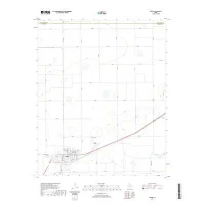
2019 Map of Friona
USGS Topo · Published 2019About this map
The town of Friona serves as the primary hub of this High Plains landscape, organized around a geometric grid of county roads and local streets. Bisecting the southern portion of the quadrangle is Railroad Rd, a corridor that historically facilitated the movement of grain and cattle from this agricultural heartland. Just north of the town center, Benger Air Park and the Friona Cem sit amidst the flat terrain, while the intermittent drainage of Frio Draw meanders across the southern boundary. The map illustrates the strictly planned nature of the Texas Panhandle, where the border between Deaf Smith Co and Parmer Co runs straight across the northern edge. This layout reveals a landscape defined by industrial-scale agriculture, where named routes like Ranch Rd 2298 and Ranch Rd 3140 connect isolated farmsteads to the central shipping point at Friona.
Find a feature on this map
48 named features on this map. Tap any name to fly to it.
Don’t see what you’re looking for? This feature index may not catch every label — zoom into the map to look around manually.
Map Details
Editions of this 2019 Friona Map
This is the sole edition of this map. No revisions or reprints were ever made.
Other maps of this area

1954 · Clovis
USGS Topo · 1:250,000

1958 · Clovis
USGS Topo · 1:250,000

1965 · Tam Anne
USGS Topo · 1:24,000

1965 · Parmerton
USGS Topo · 1:24,000

1965 · Hub
USGS Topo · 1:24,000

1965 · Twin Lakes
USGS Topo · 1:24,000

1966 · Friona
USGS Topo · 1:24,000

1966 · Summerfield
USGS Topo · 1:24,000

1970 · Chalk Hill
USGS Topo · 1:24,000

1971 · Westway
USGS Topo · 1:24,000