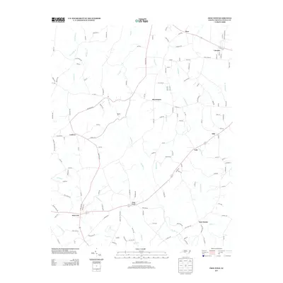
2013 Map of Frog Pond
USGS Topo · Published 2013About this map
Frog Pond and the surrounding rural communities of Stanly County are defined by a network of small watercourses like Big Bear Cr and Little Bear Cr that have shaped local agriculture and industry for generations. The legacy of local processing is represented by Whitley Mill, located near the central drainage of these creek systems. This modern survey illustrates the persistent settlement patterns of several small crossroads and named locales, including Red Cross, Bloomington, and Endy, which serve as community anchors. The landscape is primarily composed of residential and farm plots connected by an intricate web of local roads, such as Millingport Rd and Austin Rd. To the south and east, the map traces the drainages of Stony Run and Long Cr as they move toward the unincorporated community of Saint Martin.
Find a feature on this map
133 named features on this map. Tap any name to fly to it.
Don’t see what you’re looking for? This feature index may not catch every label — zoom into the map to look around manually.
Map Details
Editions of this 2013 Frog Pond Map
This is the sole edition of this map. No revisions or reprints were ever made.
Other maps of this area

1953 · Charlotte
USGS Topo · 1:250,000

1954 · Charlotte
USGS Topo · 1:250,000

1957 · Mount Pleasant
USGS Topo · 1:62,500

1957 · Albemarle
USGS Topo · 1:62,500

1960 · Charlotte
USGS Topo · 1:250,000

1962 · Charlotte
USGS Topo · 1:250,000
1971 · Stanfield
USGS Topo · 1:24,000
1971 · Oakboro
USGS Topo · 1:24,000
1971 · Aquadale
USGS Topo · 1:24,000

1977 · Albemarle SW
USGS Topo · 1:24,000