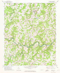
1971 Map of Stanfield
USGS Topo · Published 1973About this map
The Rocky River winds through the heart of this landscape, forming the natural boundary between Stanly, Union, and Cabarrus counties. In the early 1970s, this area reflects a rural Piedmont character defined by scattered church communities and a network of small creeks including Muddy Creek, Bear Creek, and Pumpkin Creek. The town of Stanfield sits as a primary hub along the Norfolk Southern railroad line, while Midland occupies the northwestern corner near the Pipeline corridor. The map is particularly dense with historic houses of worship that served as the social anchors for these farming communities, such as Loves Grove Ch, Friendship Ch, and Kinza Memorial Ch. Researchers can trace the winding transition of the river as it moves past Island Creek toward the southern boundary near New Salem, capturing the region just before significant suburban expansion began to reshape these traditional crossroads.
Find a feature on this map
33 named features on this map. Tap any name to fly to it.
Don’t see what you’re looking for? This feature index may not catch every label — zoom into the map to look around manually.
Map Details
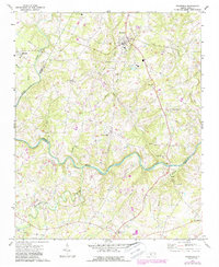
Editions of this 1971 Stanfield Map
2 editions found
Other maps of this area

1941 · Charlotte
USGS Topo · 1:125,000

1942 · Charlotte
USGS Topo · 1:125,000

1949 · Midland
USGS Topo · 1:24,000
1949 · Concord SE
USGS Topo · 1:24,000

1953 · Charlotte
USGS Topo · 1:250,000

1954 · Charlotte
USGS Topo · 1:250,000

1957 · Mount Pleasant
USGS Topo · 1:62,500

1960 · Charlotte
USGS Topo · 1:250,000

1962 · Charlotte
USGS Topo · 1:250,000
1969 · Concord SE
USGS Topo · 1:24,000