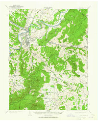
1939 Map of Front Royal
USGS Topo · Published 1965About this map
Front Royal serves as the hub of this 1930s landscape, positioned at the convergence of the North Fork and South Fork Shenandoah River. The map captures a significant period of transformation for the Blue Ridge region, documenting the early development of Skyline Drive and the Appalachian Trail alongside the establishment of the Shenandoah Homesteads Project. While the river valley supports industrial sites like the Potomac-Edison Dam and the residential tracts of Viscose City and Royal Village, the surrounding uplands remain dotted with traditional community centers.
Find a feature on this map
93 named features on this map. Tap any name to fly to it.
Don’t see what you’re looking for? This feature index may not catch every label — zoom into the map to look around manually.
Map Details
Editions of this 1939 Front Royal Map
2 editions found

Other maps of this area

1884 · Harpers Ferry
USGS Topo · 1:125,000

1891 · Harpers Ferry
USGS Topo · 1:125,000

1893 · Luray
USGS Topo · 1:125,000

1893 · Harpers Ferry
USGS Topo · 1:125,000

1894 · Warrenton
USGS Topo · 1:125,000

1894 · Warrenton
USGS Topo · 1:62,500

1894 · Winchester
USGS Topo · 1:125,000

1905 · Luray
USGS Topo · 1:125,000

1916 · Berryville
USGS Topo · 1:62,500

1923 · Middletown
USGS Topo · 1:62,500