
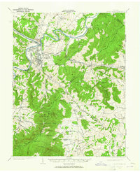
1939 Map of Front Royal
USGS Topo · Published 1939About this map
Front Royal and its surrounding mountain gaps are documented here just as the landscape was undergoing a massive shift from private farmland to federal conservation and military use. The map reveals the early footprint of Shenandoah National Park, featuring the newly constructed Skyline Drive and the Appalachian Trail winding through the Blue Ridge. To the south of the town center, the sprawling U S Army Remount Reservation occupies a significant portion of the foothills, while the Shenandoah Homesteads Project Flint Hill Unit indicates Depression-era resettlement efforts.
Find a feature on this map
137 named features on this map. Tap any name to fly to it.
Don’t see what you’re looking for? This feature index may not catch every label — zoom into the map to look around manually.
Map Details
Editions of this 1939 Front Royal Map
2 editions found
Other maps of this area

1884 · Harpers Ferry
USGS Topo · 1:125,000

1891 · Harpers Ferry
USGS Topo · 1:125,000

1893 · Luray
USGS Topo · 1:125,000

1893 · Harpers Ferry
USGS Topo · 1:125,000

1894 · Warrenton
USGS Topo · 1:125,000

1894 · Warrenton
USGS Topo · 1:62,500

1894 · Winchester
USGS Topo · 1:125,000

1905 · Luray
USGS Topo · 1:125,000

1916 · Berryville
USGS Topo · 1:62,500

1923 · Middletown
USGS Topo · 1:62,500