
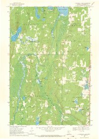
1968 Map of Frontenac Lake
USGS Topo · Published 1970About this map
The Schoolcraft River meanders through a dense corridor of wetlands and forests within the Paul Bunyan State Forest, defining the northern Minnesota wilderness of the late 1960s. The landscape is punctuated by numerous glacial lakes, including the sprawling Lake Plantagenet to the north and the centrally located Frontenac Lake. This survey illustrates the early management of the region's natural resources, shown by the designated Rockwood State Wildlife Management Areas and the placement of a Lookout Tower and Ranger Station. Human activity is concentrated around modest infrastructure like the Townhall and seasonal sites such as Camp Thunderbird. The presence of Alcohol Creek and Dead Creek feeding into the river system suggests a complex drainage network typical of the Hubbard County lakelands during this era of conservation and forest development.
Find a feature on this map
31 named features on this map. Tap any name to fly to it.
Don’t see what you’re looking for? This feature index may not catch every label — zoom into the map to look around manually.
Map Details
Editions of this 1968 Frontenac Lake Map
2 editions found
Other maps of this area

1954 · Bemidji
USGS Topo · 1:250,000

1957 · Bemidji
USGS Topo · 1:250,000

1958 · Bemidji
USGS Topo · 1:250,000

1968 · Guthrie
USGS Topo · 1:24,000

1968 · Bemidji East
USGS Topo · 1:24,000

1968 · Bemidji West
USGS Topo · 1:24,000

1972 · Laporte
USGS Topo · 1:24,000
1972 · Grant Lake
USGS Topo · 1:24,000

1972 · Lake George
USGS Topo · 1:24,000
1972 · Lake Hattie
USGS Topo · 1:24,000