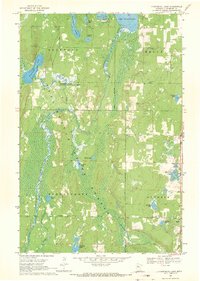
1968 Map of Frontenac Lake
USGS Topo · Published 1971About this map
Lake Plantagenet and the surrounding Hubbard County wetlands define this northern landscape, captured here during the late 1960s. The region is characterized by a dense network of water bodies and conservation lands, including the Rockwood State Wildlife Management Areas and the northern reaches of the Schoolcraft State Forest. The Schoolcraft River meanders through the western half of the quadrangle, while the Kabekona River flows through the central marshes. Civic life and resource management are marked by a Townhall and a Ranger Station in the southern portion of the map. This era shows a balance between recreational sites like Camp Thunderbird and industrial markers such as a Gravel Pit, reflecting a landscape dedicated to both public use and the natural timber and water resources of the Minnesota woods.
Find a feature on this map
27 named features on this map. Tap any name to fly to it.
Don’t see what you’re looking for? This feature index may not catch every label — zoom into the map to look around manually.
Map Details
Editions of this 1968 Frontenac Lake Map
2 editions found
Other maps of this area

1954 · Bemidji
USGS Topo · 1:250,000

1957 · Bemidji
USGS Topo · 1:250,000

1958 · Bemidji
USGS Topo · 1:250,000

1968 · Guthrie
USGS Topo · 1:24,000

1968 · Bemidji East
USGS Topo · 1:24,000

1968 · Frontenac Lake
USGS Topo · 1:24,000

1968 · Bemidji West
USGS Topo · 1:24,000

1972 · Laporte
USGS Topo · 1:24,000
1972 · Grant Lake
USGS Topo · 1:24,000

1972 · Lake George
USGS Topo · 1:24,000