
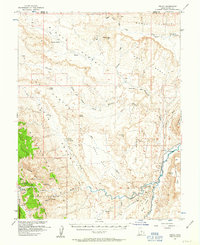
1954 Map of Fruita
USGS Topo · Published 1957About this map
Fruita serves as the primary outpost on the western edge of this 1954 survey, situated near the confluence of Sulphur Creek and the Fremont River. This landscape is dominated by the stratigraphic uplift of Capitol Reef, where erosion has carved features such as Hickman Natural Bridge and Chimney Rock. To the east, the Caineville Reef and South Caineville Mesa provide a natural barrier, while the Caineville Ditch indicates early irrigation efforts along the river flats. The map documents an era before significant paving, where travel relied on the Hartnet Trail and various unmaintained routes through Cathedral Valley and across the Red Desert. Named landmarks like Danish Hill and Miners Mountain reflect the local history of mining and prospecting in this geological complex.
Find a feature on this map
49 named features on this map. Tap any name to fly to it.
Don’t see what you’re looking for? This feature index may not catch every label — zoom into the map to look around manually.
Map Details
Editions of this 1954 Fruita Map
2 editions found
Other maps of this area

1885 · San Rafael
USGS Topo · 1:250,000

1885 · Fish Lake
USGS Topo · 1:250,000

1896 · Fish Lake
USGS Topo · 1:250,000

1952 · Notom 2 SE
USGS Topo · 1:24,000

1952 · Notom 4 NW
USGS Topo · 1:24,000

1952 · Notom 4 NE
USGS Topo · 1:24,000

1952 · Notom 2 NE
USGS Topo · 1:24,000

1952 · Notom 3 NE
USGS Topo · 1:24,000

1952 · Notom 1 SW
USGS Topo · 1:24,000

1952 · Grover
USGS Topo · 1:62,500