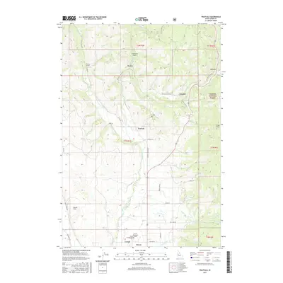
2017 Map of Fruitvale
USGS Topo · Published 2017About this map
The Weiser River valley forms the central corridor of this Adams County landscape, where the settlements of Fruitvale and Glendale occupy the lower elevations before the terrain rises into the Payette National Forest. Further north, the presence of Starkey Hot Springs at Starkey indicates the geothermal activity of the region, situated near the confluence of the W Fork Weiser River. To the south, the community of Council serves as a local hub, supported by the Council Municipal Winkler Airport and the nearby hamlet of Hoover. High ridges such as Hornet Ridge and Ft Hall Ridge frame the drainage basins of Mill Cr and Hornet Cr, illustrating a rural economy tied to the river system and timberlands. Small-scale infrastructure like Yantis Ditch and E Fork Ditch reflect the historical management of water for local agriculture and settlement.
Find a feature on this map
48 named features on this map. Tap any name to fly to it.
Don’t see what you’re looking for? This feature index may not catch every label — zoom into the map to look around manually.
Map Details
Editions of this 2017 Fruitvale Map
This is the sole edition of this map. No revisions or reprints were ever made.
Other maps of this area

1911 · Meadows
USGS Topo · 1:125,000

1954 · Council
USGS Topo · 1:62,500

1954 · New Meadows
USGS Topo · 1:62,500

1955 · Baker
USGS Topo · 1:250,000

1957 · Cambridge
USGS Topo · 1:62,500

1957 · Hornet
USGS Topo · 1:62,500

1959 · Baker
USGS Topo · 1:250,000

1980 · McCall
USGS Topo · 1:100,000

1986 · Peck Mountain
USGS Topo · 1:24,000
1986 · Council Mountain
USGS Topo · 1:24,000