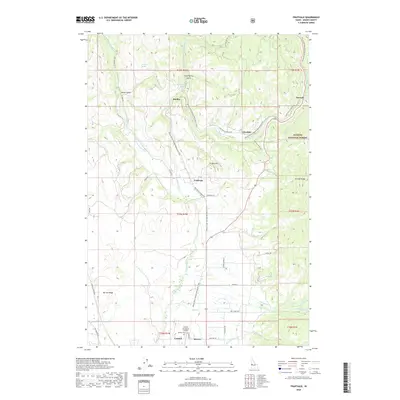
2020 Map of Fruitvale
USGS Topo · Published 2020About this map
Starkey Hot Springs and the surrounding mountain settlements of Starkey, Glendale, and Fruitvale define the rugged character of this part of Adams County. The valley is shaped by the Weiser River, which serves as a corridor for both water and transportation, including the Weiser River National Recreation Trail that follows the river's winding path. Human adaptation to the terrain is evident in the network of irrigation features like Yantis Ditch and E Fork Ditch, which support local agriculture near the Payette National Forest boundary. To the south, the community of Council is anchored by the Council Municipal Airport, while local history can be traced through the Winkler Cem and family-named landmarks such as Ft Hall Hill and Hornet Ridge.
Find a feature on this map
45 named features on this map. Tap any name to fly to it.
Don’t see what you’re looking for? This feature index may not catch every label — zoom into the map to look around manually.
Map Details
Editions of this 2020 Fruitvale Map
This is the sole edition of this map. No revisions or reprints were ever made.
Other maps of this area

1911 · Meadows
USGS Topo · 1:125,000

1954 · Council
USGS Topo · 1:62,500

1954 · New Meadows
USGS Topo · 1:62,500

1955 · Baker
USGS Topo · 1:250,000

1957 · Cambridge
USGS Topo · 1:62,500

1957 · Hornet
USGS Topo · 1:62,500

1959 · Baker
USGS Topo · 1:250,000

1980 · McCall
USGS Topo · 1:100,000

1986 · Peck Mountain
USGS Topo · 1:24,000
1986 · Council Mountain
USGS Topo · 1:24,000