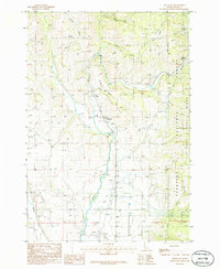
1986 Map of Fruitvale
USGS Topo · Published 1986About this map
Fruitvale and the small settlements of Starkey, Glendale, and Hoover cluster along the valley of the Weiser River during the mid-1980s. This drainage basin, where the West Fork Weiser River merges with the main channel, serves as the primary corridor for human activity and transportation through the high Idaho terrain. The western boundary of the Payette National Forest defines the eastern edge of the quadrangle, where the land rises sharply toward Fort Hall Hill and the higher timberlands.
Find a feature on this map
20 named features on this map. Tap any name to fly to it.
Don’t see what you’re looking for? This feature index may not catch every label — zoom into the map to look around manually.
Map Details
Editions of this 1986 Fruitvale Map
This is the sole edition of this map. No revisions or reprints were ever made.
Other maps of this area

1911 · Meadows
USGS Topo · 1:125,000

1954 · Council
USGS Topo · 1:62,500

1954 · New Meadows
USGS Topo · 1:62,500

1955 · Baker
USGS Topo · 1:250,000

1957 · Cambridge
USGS Topo · 1:62,500

1957 · Hornet
USGS Topo · 1:62,500

1959 · Baker
USGS Topo · 1:250,000

1980 · McCall
USGS Topo · 1:100,000

1986 · Peck Mountain
USGS Topo · 1:24,000
1986 · Council Mountain
USGS Topo · 1:24,000