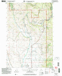
2004 Map of Fruitvale
USGS Topo · Published 2007About this map
The Weiser River valley anchors this rural Adams County landscape, where small settlements like Fruitvale and Glendale reside along the river's path. Irrigation and water management are central to the area's development, evidenced by the Yantis Ditch and various nameless canals that supported local agriculture. In the southern portion, the Council Municipal Airport and a nearby Cem mark the outskirts of the county seat, while the community of Hoover sits at the junction of river and rail. The terrain shifts dramatically from the flat river valley to the heights of Hornet Ridge and Fort Hall Ridge, much of which falls within the Payette National Forest. This era shows a landscape managed for both timber and ranching, with the New Meadows Ranger District and Council Ranger District dividing jurisdiction over these upland reaches.
Find a feature on this map
32 named features on this map. Tap any name to fly to it.
Don’t see what you’re looking for? This feature index may not catch every label — zoom into the map to look around manually.
Map Details
Editions of this 2004 Fruitvale Map
This is the sole edition of this map. No revisions or reprints were ever made.
Other maps of this area

1911 · Meadows
USGS Topo · 1:125,000

1954 · Council
USGS Topo · 1:62,500

1954 · New Meadows
USGS Topo · 1:62,500

1955 · Baker
USGS Topo · 1:250,000

1957 · Cambridge
USGS Topo · 1:62,500

1957 · Hornet
USGS Topo · 1:62,500

1959 · Baker
USGS Topo · 1:250,000

1980 · McCall
USGS Topo · 1:100,000

1986 · Peck Mountain
USGS Topo · 1:24,000
1986 · Council Mountain
USGS Topo · 1:24,000