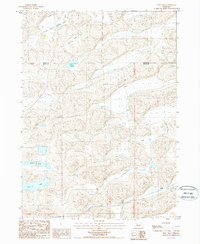
1987 Map of Frye Lake
USGS Topo · Published 1988About this map
The Middle Branch Loup River winds across the northern reaches of this landscape, marking a distinct transition in the Sandhills terrain near the border of Cherry and Grant Counties. The area is characterized by a high density of enclosed basins and seasonal water bodies, including Green Lake, Three Lakes, and Coles Lake. These hydrologic features are interspersed with numerous flowing wells, which speak to the region's reliance on the underlying aquifer for ranching and local settlement during the late twentieth century.
Find a feature on this map
12 named features on this map. Tap any name to fly to it.
Don’t see what you’re looking for? This feature index may not catch every label — zoom into the map to look around manually.
Map Details
Editions of this 1987 Frye Lake Map
This is the sole edition of this map. No revisions or reprints were ever made.
Other maps of this area

1948 · Ashby
USGS Topo · 1:62,500

1948 · George Lake
USGS Topo · 1:62,500

1948 · Whitman
USGS Topo · 1:62,500

1948 · Spring Valley
USGS Topo · 1:62,500

1949 · Ashby
USGS Topo · 1:62,500

1950 · Spring Valley
USGS Topo · 1:62,500

1950 · Whitman
USGS Topo · 1:62,500

1950 · George Lake
USGS Topo · 1:62,500

1954 · North Platte
USGS Topo · 1:250,000

1956 · North Platte
USGS Topo · 1:250,000