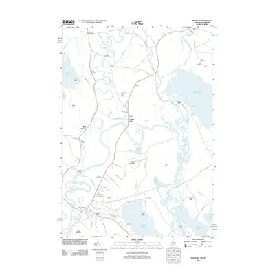
2011 Map of Fryeburg
USGS Topo · Published 2011About this map
The Saco River and its intricate Old Course Saco River dominate this New England landscape, illustrating a complex history of hydrological shifts and land use. Near the southern reaches, the primary settlement of Fryeburg is established alongside Jockey Cap and Starks Mountain, while outlying villages like North Fryeburg, West Fryeburg, and Fryeburg Center indicate a dispersed agricultural and residential pattern. Water management is a visible theme, evidenced by the Fryeburg Dam, the Kezar River Mill Dam at the northern edge, and the Swans Falls Dam near the Fryeburg Fairgrounds. Numerous family and community burial grounds, such as Riverside Cemetery, Abbot Cemeteries, and the Wiley Cemetery, are scattered across the terrain, offering significant points of interest for genealogical research. The map also captures the transition between the lowlands of Bog Pond and the elevations of Mount Tom, framing a region defined by its reliance on the river system.
Find a feature on this map
92 named features on this map. Tap any name to fly to it.
Don’t see what you’re looking for? This feature index may not catch every label — zoom into the map to look around manually.
Map Details
Editions of this 2011 Fryeburg Map
This is the sole edition of this map. No revisions or reprints were ever made.
Other maps of this area

1894 · North Conway
USGS Topo · 1:62,500

1896 · North Conway
USGS Topo · 1:62,500

1909 · Fryeburg
USGS Topo · 1:62,500

1910 · Kezar Falls
USGS Topo · 1:48,000

1911 · Fryeburg
USGS Topo · 1:62,500

1911 · Kezar Falls
USGS Topo · 1:62,500

1930 · Ossipee Lake
USGS Topo · 1:62,500

1941 · Fryeburg
USGS Topo · 1:62,500

1942 · North Conway
USGS Topo · 1:62,500

1945 · North Conway
USGS Topo · 1:62,500