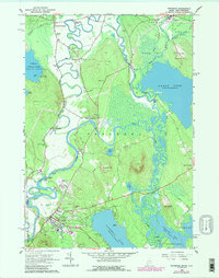
1963 Map of Fryeburg
USGS Topo · Published 1989About this map
The Saco River dominates this region of Oxford County, carving a complex path through the valley as evidenced by the Old Course Saco River and numerous oxbow features like Horseshoe Pond. In the southern portion of the sheet, the village of Fryeburg serves as a focal point for the surrounding agricultural and residential landscape, containing notable institutions such as Fryeburg Academy and the local Fairgrounds. The map details a network of early settlements including North Fryeburg, West Fryeburg, and Fryeburg Center, each supported by several family-named burial grounds like Abbot Cems and Bradley Cem.
Find a feature on this map
61 named features on this map. Tap any name to fly to it.
Don’t see what you’re looking for? This feature index may not catch every label — zoom into the map to look around manually.
Map Details
Editions of this 1963 Fryeburg Map
2 editions found
Other maps of this area

1894 · North Conway
USGS Topo · 1:62,500

1896 · North Conway
USGS Topo · 1:62,500

1909 · Fryeburg
USGS Topo · 1:62,500

1910 · Kezar Falls
USGS Topo · 1:48,000

1911 · Fryeburg
USGS Topo · 1:62,500

1911 · Kezar Falls
USGS Topo · 1:62,500

1930 · Ossipee Lake
USGS Topo · 1:62,500

1941 · Fryeburg
USGS Topo · 1:62,500

1942 · North Conway
USGS Topo · 1:62,500

1945 · North Conway
USGS Topo · 1:62,500