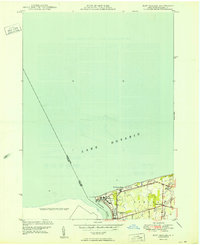
1950 Map of Ft Niagara
USGS Topo · Published 1950About this map
Old Fort Niagara stands at the strategic confluence where the Niagara River meets Lake Ontario, marking a historic site of international importance. This mid-century survey illustrates the interface between military history and the developing recreational landscape of Niagara County. The grounds of Fort Niagara are surrounded by the expanding Fort Niagara State Park, while the adjacent village of Youngstown shows a clear residential grid including Elm St and Lake Road.
Find a feature on this map
18 named features on this map. Tap any name to fly to it.
Don’t see what you’re looking for? This feature index may not catch every label — zoom into the map to look around manually.
Map Details
Editions of this 1950 Ft Niagara Map
This is the sole edition of this map. No revisions or reprints were ever made.
Other maps of this area

1894 · Niagara Falls
USGS Topo · 1:62,500

1894 · Wilson
USGS Topo · 1:62,500

1896 · Niagara Falls
USGS Topo · 1:62,500

1897 · Tonawanda
USGS Topo · 1:62,500

1899 · Niagara
USGS Topo · 1:125,000

1900 · Wilson
USGS Topo · 1:62,500

1900 · Tonawanda
USGS Topo · 1:62,500

1900 · Niagara Falls
USGS Topo · 1:62,500

1901 · Niagara Falls
USGS Topo · 1:62,500

1901 · Tonawanda
USGS Topo · 1:62,500