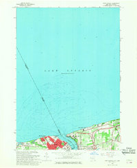
1965 Map of Ft Niagara
USGS Topo · Published 1968About this map
The Niagara River serves as the focal point for this international boundary survey, where the United States-Canada border bisects the river's path into Lake Ontario. At this strategic mouth, the historical military significance of the region is evident through the presence of Old Fort Niagara on the American shore and Fort Mississauga on the Canadian side at Mississauga Point. The landscape reflects a mid-century transition toward recreation and preservation, with Fort Niagara State Park and Fourmile Creek State Park established along the coastline.
Find a feature on this map
28 named features on this map. Tap any name to fly to it.
Don’t see what you’re looking for? This feature index may not catch every label — zoom into the map to look around manually.
Map Details
Editions of this 1965 Ft Niagara Map
This is the sole edition of this map. No revisions or reprints were ever made.
Other maps of this area

1894 · Niagara Falls
USGS Topo · 1:62,500

1894 · Wilson
USGS Topo · 1:62,500

1896 · Niagara Falls
USGS Topo · 1:62,500

1897 · Tonawanda
USGS Topo · 1:62,500

1899 · Niagara
USGS Topo · 1:125,000

1900 · Wilson
USGS Topo · 1:62,500

1900 · Tonawanda
USGS Topo · 1:62,500

1900 · Niagara Falls
USGS Topo · 1:62,500

1901 · Niagara Falls
USGS Topo · 1:62,500

1901 · Tonawanda
USGS Topo · 1:62,500