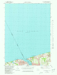
1980 Map of Ft Niagara
USGS Topo · Published 1980About this map
Niagara-On-The-Lake and the village of Youngstown anchor this international survey where the Niagara River empties into Lake Ontario. The map documents a heavily fortified and institutional landscape, marked by Fort Niagara State Park and Fort George Park on opposing banks. The Canadian side features the Department of National Defense grounds and an extensive Rifle Range along the shore at Mississauga Beach. On the New York side, the Robert Moses Parkway sweeps through the terrain toward Fourmile Creek State Park. Notable maritime landmarks include the Coast Guard Sta, a Lighthouse, and a Marina situated within the river's mouth. The residential growth around Towers Corners and the preservation of Historic Site locations reveal the intersection of modern recreation and deep-seated border history in this 1980 edition.
Find a feature on this map
32 named features on this map. Tap any name to fly to it.
Don’t see what you’re looking for? This feature index may not catch every label — zoom into the map to look around manually.
Map Details
Editions of this 1980 Ft Niagara Map
This is the sole edition of this map. No revisions or reprints were ever made.
Other maps of this area

1894 · Niagara Falls
USGS Topo · 1:62,500

1894 · Wilson
USGS Topo · 1:62,500

1896 · Niagara Falls
USGS Topo · 1:62,500

1897 · Tonawanda
USGS Topo · 1:62,500

1899 · Niagara
USGS Topo · 1:125,000

1900 · Wilson
USGS Topo · 1:62,500

1900 · Tonawanda
USGS Topo · 1:62,500

1900 · Niagara Falls
USGS Topo · 1:62,500

1901 · Niagara Falls
USGS Topo · 1:62,500

1901 · Tonawanda
USGS Topo · 1:62,500