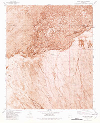
1981 Map of Fuller Ranch
USGS Topo · Published 1982About this map
Lava flows dominate the northern half of this high-desert landscape on the border of Socorro and Sierra counties. This orthophotomap, based on aerial photography from the early 1970s, captures the stark interface between the volcanic terrain and the grazing lands of the Pedro Armendaris No 33 land grant. Human activity is defined by the vital necessity of water, evidenced by remote outposts like Fuller Ranch and several scattered water sources including Chavez Well and Malpais Well. The presence of a Jeep Trail suggests the difficulty of travel across this arid basin. Much of the southern portion of the sheet is occupied by the White Sands Missile Range, highlighting the transition from traditional ranching to restricted military use in this corner of New Mexico.
Find a feature on this map
11 named features on this map. Tap any name to fly to it.
Don’t see what you’re looking for? This feature index may not catch every label — zoom into the map to look around manually.
Map Details
Editions of this 1981 Fuller Ranch Map
2 editions found
Other maps of this area

1916 · Salinas Peak
USGS Topo · 1:125,000

1948 · Granjean Well
USGS Topo · 1:62,500

1948 · Val Verde
USGS Topo · 1:62,500

1948 · Malpais Well
USGS Topo · 1:62,500

1948 · Salinas Peak
USGS Topo · 1:62,500

1954 · Tularosa
USGS Topo · 1:250,000

1958 · Tularosa
USGS Topo · 1:250,000

1981 · Big Gyp Mountain
USGS Topo · 1:24,000
1981 · Fence Canyon
USGS Topo · 1:24,000
1981 · Fairview Well
USGS Topo · 1:24,000