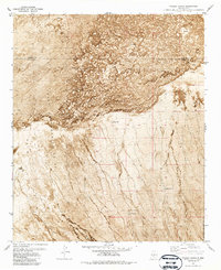
1981 Map of Fuller Ranch
USGS Topo · Published 1987About this map
The Pedro Armendaris No 33 land grant dominates this high-desert landscape on the border of Socorro and Sierra counties. This orthophotomap, produced from aerial photography taken in the early 1970s, provides a unique visual record of the stark volcanic geography defined by massive flows of Lava. The northern half of the sheet is almost entirely covered by these textured geological formations, which give way to a network of drainage patterns and isolated water points further south.
Find a feature on this map
11 named features on this map. Tap any name to fly to it.
Don’t see what you’re looking for? This feature index may not catch every label — zoom into the map to look around manually.
Map Details
Editions of this 1981 Fuller Ranch Map
2 editions found
Other maps of this area

1916 · Salinas Peak
USGS Topo · 1:125,000

1948 · Granjean Well
USGS Topo · 1:62,500

1948 · Val Verde
USGS Topo · 1:62,500

1948 · Malpais Well
USGS Topo · 1:62,500

1948 · Salinas Peak
USGS Topo · 1:62,500

1954 · Tularosa
USGS Topo · 1:250,000

1958 · Tularosa
USGS Topo · 1:250,000

1981 · Big Gyp Mountain
USGS Topo · 1:24,000
1981 · Fence Canyon
USGS Topo · 1:24,000
1981 · Fairview Well
USGS Topo · 1:24,000