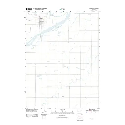
2011 Map of Fullerton
USGS Topo · Published 2011About this map
The town of Fullerton sits at the confluence of the Cedar River and Loup River in Nance County, Nebraska. This 2011 survey illustrates the grid-style development of the town, featuring local landmarks such as the Fullerton Post Office and its proximity to the water systems that define the region's geography. South of the main settlement, the landscape transitions into agricultural terrain bisected by the winding course of Prairie Creek. Genealogists and local historians will find the Bureau Cemetery located south of the Loup River, providing a specific point of reference for family research in this rural corridor. The map's road network, including Co HWY-p122 and numerous rural routes like 18th RD and Z RD, outlines the modern infrastructure supporting the farming community.
Find a feature on this map
23 named features on this map. Tap any name to fly to it.
Don’t see what you’re looking for? This feature index may not catch every label — zoom into the map to look around manually.
Map Details
Editions of this 2011 Fullerton Map
This is the sole edition of this map. No revisions or reprints were ever made.
Other maps of this area

1896 · Stromsburg
USGS Topo · 1:125,000

1899 · St. Paul
USGS Topo · 1:125,000

1954 · Belgrade
USGS Topo · 1:24,000

1955 · Broken Bow
USGS Topo · 1:250,000

1955 · Belgrade SE
USGS Topo · 1:24,000

1955 · Fremont
USGS Topo · 1:250,000

1956 · Broken Bow
USGS Topo · 1:250,000

1957 · Fremont
USGS Topo · 1:250,000

1958 · Fremont
USGS Topo · 1:250,000
1958 · Merchiston
USGS Topo · 1:24,000