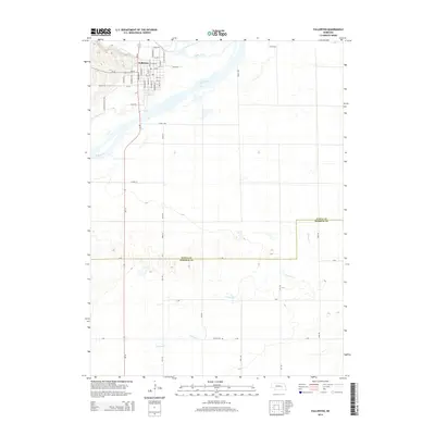
2014 Map of Fullerton
USGS Topo · Published 2014About this map
Fullerton sits at the northern edge of this Nebraska landscape, uniquely situated between the converging flows of the Cedar River and the Loup River. The town’s orderly street grid, including N Broadway St and Irving St, contrasts with the winding waterways that define the regional geography. This survey documents the area's agricultural character, with numerous rural roads like Pleasant Valley Rd and Road 2490 providing access to the fertile plains south of the rivers. The southern portion of the map transitions into the drainage basin for Prairie Cr, where the small Bureau Cem serves as a quiet record of local heritage. The boundary between Nance Co and Merrick Co is clearly delineated across these prairies, illustrating the jurisdictional divisions that have governed this ranching and farming country for generations.
Find a feature on this map
47 named features on this map. Tap any name to fly to it.
Don’t see what you’re looking for? This feature index may not catch every label — zoom into the map to look around manually.
Map Details
Editions of this 2014 Fullerton Map
This is the sole edition of this map. No revisions or reprints were ever made.
Other maps of this area

1896 · Stromsburg
USGS Topo · 1:125,000

1899 · St. Paul
USGS Topo · 1:125,000

1954 · Belgrade
USGS Topo · 1:24,000

1955 · Broken Bow
USGS Topo · 1:250,000

1955 · Belgrade SE
USGS Topo · 1:24,000

1955 · Fremont
USGS Topo · 1:250,000

1956 · Broken Bow
USGS Topo · 1:250,000

1957 · Fremont
USGS Topo · 1:250,000

1958 · Fremont
USGS Topo · 1:250,000
1958 · Merchiston
USGS Topo · 1:24,000