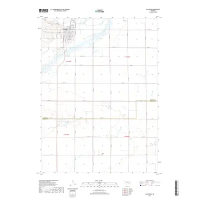
2017 Map of Fullerton
USGS Topo · Published 2017About this map
Fullerton sits at the northern edge of this landscape, established near the confluence of the Cedar River and the Loup River. The river systems dominate the geography, carving broad valleys across the terrain. To the south, the land transitions into more open country, eventually crossing from Nance Co into Merrick Co. The map reveals a structured grid of rural roads, such as S 550th ST and 590th ST, which connect outlying agricultural areas to the town center. A significant local landmark, the Bureau Cem, is located in the southern portion of the quadrangle near Prairie Cr. This 2017 survey reflects the enduring spatial organization of Nance County, where the relationship between the town of Fullerton and the surrounding waterways continues to dictate the local infrastructure and land use patterns.
Find a feature on this map
36 named features on this map. Tap any name to fly to it.
Don’t see what you’re looking for? This feature index may not catch every label — zoom into the map to look around manually.
Map Details
Editions of this 2017 Fullerton Map
This is the sole edition of this map. No revisions or reprints were ever made.
Other maps of this area

1896 · Stromsburg
USGS Topo · 1:125,000

1899 · St. Paul
USGS Topo · 1:125,000

1954 · Belgrade
USGS Topo · 1:24,000

1955 · Broken Bow
USGS Topo · 1:250,000

1955 · Belgrade SE
USGS Topo · 1:24,000

1955 · Fremont
USGS Topo · 1:250,000

1956 · Broken Bow
USGS Topo · 1:250,000

1957 · Fremont
USGS Topo · 1:250,000

1958 · Fremont
USGS Topo · 1:250,000
1958 · Merchiston
USGS Topo · 1:24,000