
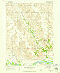
1958 Map of Fullerton
USGS Topo · Published 1959About this map
Fullerton serves as the focal point of this late-1950s survey, situated at the confluence of the Loup River and the Cedar River. This river-defined landscape in Nance and Merrick Counties is deeply tied to the Union Pacific rail line, which borders the town and crosses the waterways. The surrounding rural townships, including West Newman and East Newman, are marked by a dense network of country schoolhouses such as School No 25, Red Top Sch, and Elm Grove Sch, illustrating the dispersed settlement pattern of Nebraska's farming communities before the era of widespread school consolidation. Further south across Prairie Creek, the map details the rural infrastructure of Clarksville and Mead, featuring Pierce Chapel, the Bureau Cemetery, and the Pleasant Hill High Sch. These family and community landmarks, alongside numerous sand and gravel pits, provide a clear record of the local economy and genealogy of the Platte River valley periphery.
Find a feature on this map
23 named features on this map. Tap any name to fly to it.
Don’t see what you’re looking for? This feature index may not catch every label — zoom into the map to look around manually.
Map Details
Editions of this 1958 Fullerton Map
This is the sole edition of this map. No revisions or reprints were ever made.
Other maps of this area

1896 · Stromsburg
USGS Topo · 1:125,000

1899 · St. Paul
USGS Topo · 1:125,000

1954 · Belgrade
USGS Topo · 1:24,000

1955 · Broken Bow
USGS Topo · 1:250,000

1955 · Belgrade SE
USGS Topo · 1:24,000

1955 · Fremont
USGS Topo · 1:250,000

1956 · Broken Bow
USGS Topo · 1:250,000

1957 · Fremont
USGS Topo · 1:250,000

1958 · Fremont
USGS Topo · 1:250,000
1958 · Merchiston
USGS Topo · 1:24,000