
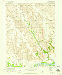
1958 Map of Fullerton NE
USGS Topo · Published 1959About this map
The Loup River valley dominates this portion of Nance County, where the river's broad floodplain is protected by a complex system of embankments and a large irrigation Canal. In the late 1950s, the rural landscape was characterized by a dense network of one-room schoolhouses, suggesting a thriving agricultural community. Schools such as Skeedee View Sch, Plainview Sch, and Shady Nook Sch are scattered across the terrain, serving the families living between the dissected uplands of Council Creek and the flat bottomlands. The Union Pacific railroad parallels the river, providing the essential transport link for grain and livestock. The intricate meandering of Beaver Creek and Skeedee Creek through the northern hills creates a stark contrast to the engineered stability of the river valley to the south.
Find a feature on this map
21 named features on this map. Tap any name to fly to it.
Don’t see what you’re looking for? This feature index may not catch every label — zoom into the map to look around manually.
Map Details
Editions of this 1958 Fullerton NE Map
This is the sole edition of this map. No revisions or reprints were ever made.
Other maps of this area

1896 · Stromsburg
USGS Topo · 1:125,000

1955 · Fremont
USGS Topo · 1:250,000

1957 · Fremont
USGS Topo · 1:250,000

1958 · Fremont
USGS Topo · 1:250,000

1958 · Genoa
USGS Topo · 1:24,000
1958 · Merchiston
USGS Topo · 1:24,000

1958 · Fullerton
USGS Topo · 1:24,000

1958 · Silver Creek
USGS Topo · 1:24,000

1958 · Havens
USGS Topo · 1:24,000

1958 · St. Edward
USGS Topo · 1:24,000