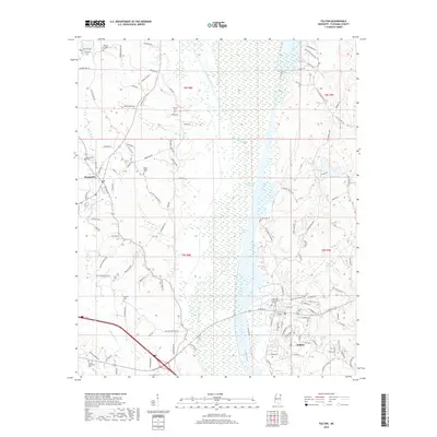
2018 Map of Fulton
USGS Topo · Published 2018About this map
Fulton and Mantachie anchor this portion of Itawamba County, where the modern landscape is defined by the engineered path of the Tombigbee River. The river corridor, featuring the Old River Cutoff and Queen Lake, shows the complex hydrology and navigation improvements of the region. On the higher ground west of the river, a network of family-named roads like Buster Bean Rd and Kirksey Rd connects long-established rural community centers. Genealogists will find a significant concentration of burial grounds throughout the area, including Fulton Cem, Mantachie Cem, and the Dorsey Memorial Cem near the southern edge. The presence of Itawamba Community College in Fulton indicates the town's role as a regional educational hub, while smaller landmarks like Warren Chapel and the Water Plant highlight the local infrastructure and social centers.
Find a feature on this map
120 named features on this map. Tap any name to fly to it.
Don’t see what you’re looking for? This feature index may not catch every label — zoom into the map to look around manually.
Map Details
Editions of this 2018 Fulton Map
This is the sole edition of this map. No revisions or reprints were ever made.
Other maps of this area

1921 · Tupelo
USGS Topo · 1:48,000

1923 · Tupelo
USGS Topo · 1:62,500

1956 · Tupelo
USGS Topo · 1:250,000

1958 · Tupelo
USGS Topo · 1:250,000

1965 · Mooreville
USGS Topo · 1:24,000

1965 · Fulton SE
USGS Topo · 1:24,000

1965 · Fulton
USGS Topo · 1:24,000
1965 · Fulton NE
USGS Topo · 1:24,000

1965 · Kirkville
USGS Topo · 1:24,000

1966 · Beans Ferry
USGS Topo · 1:24,000