
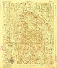
1923 Map of Tupelo
USGS Topo · Published 1923About this map
Tupelo serves as the focal point for this early 1920s landscape, positioned at the junction of the St Louis San Francisco RR and the Mobile and Ohio RR. The map captures a transition period in northeast Mississippi, where agricultural life is deeply anchored by small rural institutions like the New Prospect Church, Beulah School, and the County Farm. To the north, the rail line connects established centers such as Saltillo and Guntown, while the surrounding countryside is defined by an intricate network of waterways including Oldtown Creek and the South Tulip Creek. Genealogists will find significant value in the distribution of family-named landmarks and rural gathering places, from the Campbelltown Cemetery to isolated commercial outposts like Parkers Store and Kirks Gin. This survey documents the region before modern highway expansion, preserving the original locations of numerous country schools like the Bryson School and Pratt School that once dotted the Lee County interior.
Find a feature on this map
82 named features on this map. Tap any name to fly to it.
Don’t see what you’re looking for? This feature index may not catch every label — zoom into the map to look around manually.
Map Details
Editions of this 1923 Tupelo Map
2 editions found
Other maps of this area

1921 · Booneville
USGS Topo · 1:48,000

1921 · Tupelo
USGS Topo · 1:48,000

1922 · Booneville
USGS Topo · 1:62,500

1955 · Ripley
USGS Topo · 1:62,500

1955 · Sherman
USGS Topo · 1:62,500

1956 · Tupelo
USGS Topo · 1:250,000

1958 · Tupelo
USGS Topo · 1:250,000

1965 · Mooreville
USGS Topo · 1:24,000

1965 · Fulton
USGS Topo · 1:24,000
1965 · Marietta
USGS Topo · 1:24,000