
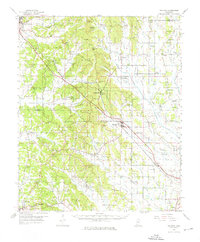
1955 Map of Sherman
USGS Topo · Published 1956About this map
The St Louis San Francisco railroad cuts a diagonal path through this corner of Northeast Mississippi, connecting the larger hubs of New Albany and Tupelo through several smaller railway settlements. Communities like Wallerville, Blue Springs, and Sherman are situated along this critical transport corridor, which paralleled U.S. Route 78 during the mid-1950s. The landscape is defined by its transition from the higher elevations of Birmingham Ridge and Rakestraw Mountain down into the expansive lowlands of Coonewar Bottom and Wilson Bottom.
Find a feature on this map
130 named features on this map. Tap any name to fly to it.
Don’t see what you’re looking for? This feature index may not catch every label — zoom into the map to look around manually.
Map Details
Editions of this 1955 Sherman Map
2 editions found
Other maps of this area

1921 · Booneville
USGS Topo · 1:48,000

1921 · Tupelo
USGS Topo · 1:48,000

1922 · Booneville
USGS Topo · 1:62,500

1923 · Tupelo
USGS Topo · 1:62,500

1949 · New Albany
USGS Topo · 1:62,500

1951 · New Albany
USGS Topo · 1:62,500

1955 · Ripley
USGS Topo · 1:62,500

1955 · Blue Mountain
USGS Topo · 1:62,500

1956 · Tupelo
USGS Topo · 1:250,000

1958 · Tupelo
USGS Topo · 1:250,000