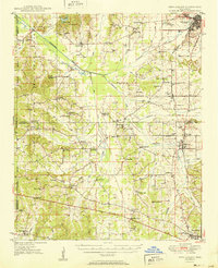
1949 Map of New Albany
USGS Topo · Published 1964About this map
New Albany anchors the northeastern corner of this northern Mississippi landscape, where the Gulf Mobile and Ohio railroad corridor serves as a primary transit artery through Union and Pontotoc Counties. The topography is defined by the winding course of the Tallahatchie River and its numerous tributaries, such as Hell Creek and Lappatubby Creek. Significant portions of the western terrain are preserved within the Holly Springs National Forest, contrasting with the surrounding agricultural and rural patchwork.
Find a feature on this map
78 named features on this map. Tap any name to fly to it.
Don’t see what you’re looking for? This feature index may not catch every label — zoom into the map to look around manually.
Map Details
Editions of this 1949 New Albany Map
This is the sole edition of this map. No revisions or reprints were ever made.