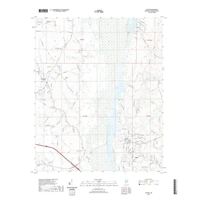
2021 Map of Fulton
USGS Topo · Published 2021About this map
Fulton serves as the focal point of this Itawamba County landscape, anchored by the Itawamba County Courthouse and the sprawling campus of Itawamba Community College. The settlement pattern is defined by the winding course of the Tishomingo River and the broad wetlands of the Old River Cutoff, which create a distinct north-south corridor of bottomlands. To the northwest, the town of Mantachie sits near the headwaters of Mantachie Creek, surrounded by a network of rural roads such as Buster Bean Rd and Thrasher Rd.
Find a feature on this map
119 named features on this map. Tap any name to fly to it.
Don’t see what you’re looking for? This feature index may not catch every label — zoom into the map to look around manually.
Map Details
Editions of this 2021 Fulton Map
This is the sole edition of this map. No revisions or reprints were ever made.
Other maps of this area

1921 · Tupelo
USGS Topo · 1:48,000

1923 · Tupelo
USGS Topo · 1:62,500

1956 · Tupelo
USGS Topo · 1:250,000

1958 · Tupelo
USGS Topo · 1:250,000

1965 · Mooreville
USGS Topo · 1:24,000

1965 · Fulton SE
USGS Topo · 1:24,000

1965 · Fulton
USGS Topo · 1:24,000
1965 · Fulton NE
USGS Topo · 1:24,000

1965 · Kirkville
USGS Topo · 1:24,000

1966 · Beans Ferry
USGS Topo · 1:24,000