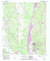
1992 Map of Fulton
USGS Topo · Published 1995About this map
The Tennessee-Tombigbee Waterway dominates this portion of Mississippi, fundamentally altering the local landscape where the Tombigbee River once meandered naturally. Modern revisions captured in 1990 show the expansion of the Fulton city limits and the sprawling campus of Itawamba Community College. The map preserves the complex hydrologic character of the basin, from the remnant Old River Cutoff to the managed wetlands of the John Bell Williams State Wildlife Management Area.
Find a feature on this map
47 named features on this map. Tap any name to fly to it.
Don’t see what you’re looking for? This feature index may not catch every label — zoom into the map to look around manually.
Map Details
Editions of this 1992 Fulton Map
This is the sole edition of this map. No revisions or reprints were ever made.
Other maps of this area

1921 · Tupelo
USGS Topo · 1:48,000

1923 · Tupelo
USGS Topo · 1:62,500

1956 · Tupelo
USGS Topo · 1:250,000

1958 · Tupelo
USGS Topo · 1:250,000

1965 · Mooreville
USGS Topo · 1:24,000

1965 · Fulton SE
USGS Topo · 1:24,000

1965 · Fulton
USGS Topo · 1:24,000
1965 · Fulton NE
USGS Topo · 1:24,000

1965 · Kirkville
USGS Topo · 1:24,000

1966 · Beans Ferry
USGS Topo · 1:24,000