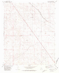
1981 Map of Gacho Hill
USGS Topo · Published 1981About this map
Gacho Hill serves as the central landmark for this arid expanse of Guadalupe County during the early 1980s. The landscape is defined by the infrastructure of the Atchison Topeka and Santa Fe railroad, which cuts diagonally across the northern terrain, passing through the siding or stop identified as Joffre. Water management is critical in this high-desert environment, evidenced by scattered improvements like the Seven Lakes Well, Gacho Well, and various storage tanks located near the topographic rises. The presence of a Gravel Pit and a location marked Derrick suggests localized industrial or exploratory activity typical of the region's resource-based economy during this era. This survey, based on 1973 photography, captures the sparse but intentional distribution of ranching and transport features that sustained the local community.
Find a feature on this map
8 named features on this map. Tap any name to fly to it.
Don’t see what you’re looking for? This feature index may not catch every label — zoom into the map to look around manually.
Map Details
Editions of this 1981 Gacho Hill Map
This is the sole edition of this map. No revisions or reprints were ever made.
Other maps of this area

1954 · Fort Sumner
USGS Topo · 1:250,000

1958 · Fort Sumner
USGS Topo · 1:250,000

1978 · Vaughn
USGS Topo · 1:24,000

1978 · El Morro Ranch
USGS Topo · 1:24,000

1978 · Long Draw
USGS Topo · 1:24,000

1979 · Fort Sumner
USGS Topo · 1:100,000

1980 · Corona
USGS Topo · 1:100,000

1981 · Loco Draw
USGS Topo · 1:24,000

1981 · Gacho Hill NW
USGS Topo · 1:24,000

1981 · Gacho Hill SW
USGS Topo · 1:24,000