
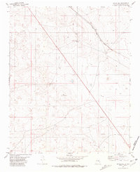
1981 Map of Loco Draw
USGS Topo · Published 1981About this map
Mile High Ranch anchors this high-plains landscape in the early 1980s, situated near the intersection of the Guadalupe Co Lincoln Co and Lincoln Co De Baca Co lines. The terrain is defined by its water management systems, essential for cattle ranching in this arid environment. A series of catchment features and livestock watering points like Barvel Lake, Cantina Tank, and the Meadow Pasture Tanks dot the drainage of Loco Draw. Wind-powered infrastructure is prominent, with several wells marked as West Pasture Windmill and Twin Windmills providing critical water sources across the sections. The industrial presence is limited to a straight-line Pipeline and a small Gravel Pit, reflecting a landscape primarily dedicated to open-range livestock production rather than dense settlement.
Find a feature on this map
16 named features on this map. Tap any name to fly to it.
Don’t see what you’re looking for? This feature index may not catch every label — zoom into the map to look around manually.
Map Details
Editions of this 1981 Loco Draw Map
This is the sole edition of this map. No revisions or reprints were ever made.
Other maps of this area

1954 · Fort Sumner
USGS Topo · 1:250,000

1958 · Fort Sumner
USGS Topo · 1:250,000

1967 · Ramon
USGS Topo · 1:24,000

1967 · Wright Ranch
USGS Topo · 1:24,000

1979 · Fort Sumner
USGS Topo · 1:100,000

1980 · Corona
USGS Topo · 1:100,000

1981 · Cowboy Mesa NE
USGS Topo · 1:24,000

1981 · Gacho Hill SE
USGS Topo · 1:24,000

1981 · Yeso Mesa
USGS Topo · 1:24,000
1981 · Gacho Hill
USGS Topo · 1:24,000