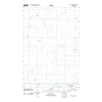
2011 Map of Gackle North
USGS Topo · Published 2011About this map
The settlement of Gackle anchors the southern edge of this North Dakota landscape, where the town's residential core is defined by streets such as Front St E and Elm St E. North of the town center, the terrain is characterized by a high density of small, scattered wetlands and basins, a common feature of the Prairie Pothole Region. This agricultural and rural environment is supported by a precise grid of section-line roads, including 58th Ave SE and 46th St SE. For local historians and genealogists, the map identifies specific community landmarks such as the United Methodist Cemetery and Streeter Cemetery. Aviation history is represented by the Enzminger Landing Strip, which sits along 59th Ave SE amidst the rolling terrain of Logan County.
Find a feature on this map
29 named features on this map. Tap any name to fly to it.
Don’t see what you’re looking for? This feature index may not catch every label — zoom into the map to look around manually.
Map Details
Editions of this 2011 Gackle North Map
This is the sole edition of this map. No revisions or reprints were ever made.
Other maps of this area

1953 · Jamestown
USGS Topo · 1:250,000

1953 · Cleveland SE
USGS Topo · 1:24,000

1953 · Cleveland SW
USGS Topo · 1:24,000

1955 · Medina SE
USGS Topo · 1:24,000

1956 · Jamestown
USGS Topo · 1:250,000

1983 · Alfred
USGS Topo · 1:24,000

1983 · Streeter
USGS Topo · 1:24,000

1983 · Gackle North
USGS Topo · 1:24,000

1983 · Streeter SE
USGS Topo · 1:24,000
1983 · Gackle South
USGS Topo · 1:24,000