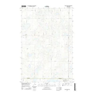
2014 Map of Gackle North
USGS Topo · Published 2014About this map
Gackle anchors the southern edge of this North Dakota landscape, situated along the border of Stutsman Co and Logan Co. The area is characterized by a dense concentration of prairie potholes and small water bodies that dictate the grid of rural roads, including Neu Dorf Rd and Hy 46 Se. Local heritage is preserved at the United Methodist Cem and the Streeter Cem, which serve as quiet landmarks among the agricultural fields. The map detail extends to the town's street plan, showing named corridors like Birch St W and Maple St E, providing a clear view of the community's layout just north of the county line.
Find a feature on this map
23 named features on this map. Tap any name to fly to it.
Don’t see what you’re looking for? This feature index may not catch every label — zoom into the map to look around manually.
Map Details
Editions of this 2014 Gackle North Map
This is the sole edition of this map. No revisions or reprints were ever made.
Other maps of this area

1953 · Jamestown
USGS Topo · 1:250,000

1953 · Cleveland SE
USGS Topo · 1:24,000

1953 · Cleveland SW
USGS Topo · 1:24,000

1955 · Medina SE
USGS Topo · 1:24,000

1956 · Jamestown
USGS Topo · 1:250,000

1983 · Alfred
USGS Topo · 1:24,000

1983 · Streeter
USGS Topo · 1:24,000

1983 · Gackle North
USGS Topo · 1:24,000

1983 · Streeter SE
USGS Topo · 1:24,000
1983 · Gackle South
USGS Topo · 1:24,000