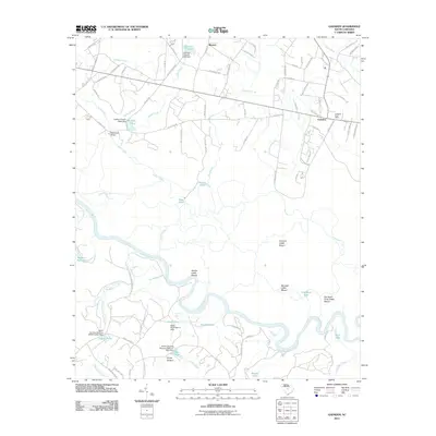
2011 Map of Gadsden
USGS Topo · Published 2011About this map
The Congaree River corridor dominates this 2011 survey, revealing a landscape defined by its floodplain and the high-water refuges known as cattle mounts. These man-made earthen mounds, including Cooners Cattle Mount, Bradys Cattle Mount, and Big Lake Cattle Mount, reflect a specialized agricultural adaptation for grazing livestock in the low-lying basin. The settlement of Gadsden sits at a higher elevation to the northeast, anchored by the Gadsden Post Office and a network of rural routes such as Old Bluff Rd and S Cedar Creek Rd.
Find a feature on this map
91 named features on this map. Tap any name to fly to it.
Don’t see what you’re looking for? This feature index may not catch every label — zoom into the map to look around manually.
Map Details
Editions of this 2011 Gadsden Map
This is the sole edition of this map. No revisions or reprints were ever made.
Other maps of this area

1943 · Eastover
USGS Topo · 1:62,500

1946 · Elloree
USGS Topo · 1:62,500

1946 · St. Matthews
USGS Topo · 1:62,500

1948 · Hopkins
USGS Topo · 1:62,500

1953 · Saylors Lake
USGS Topo · 1:24,000

1953 · Fort Jackson South
USGS Topo · 1:24,000

1953 · Eastover
USGS Topo · 1:24,000
1953 · Congaree
USGS Topo · 1:24,000

1953 · Gadsden
USGS Topo · 1:24,000

1953 · Wateree
USGS Topo · 1:24,000