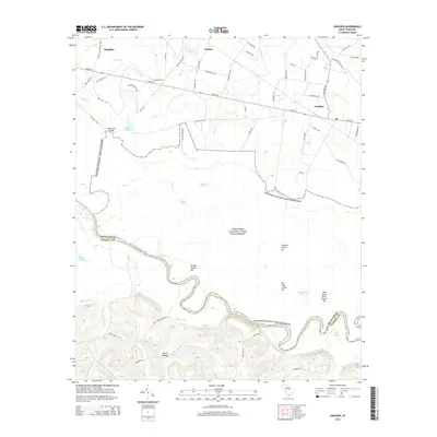
2014 Map of Gadsden
USGS Topo · Published 2014About this map
Congaree National Park Wilderness dominates the southern landscape of this Richland County area, where the meandering Congaree River forms the border with Calhoun County. The terrain is defined by the contrast between the low-lying wetlands of the Congaree basin and the rising elevations to the north and south. In the bottomlands, an intricate network of oxbow lakes and named high ground like Cooners Cattle Mt and Bradys Cattle Mt indicates the historical importance of seasonal grazing in these flood-prone areas. Settlements like Gadsden and Hopkins are situated on higher ground to the north, connected by a web of local routes such as Bluff Rd and Congaree Rd. Water features are abundant throughout, from Weston Lake and Wise Lake in the park to Duffies Pond and Clarkson Pond near the smaller communities. The map also captures several family-named landmarks, including Bannisters Bridge and Buyck Bottom, which offer valuable geographic markers for local historians.
Find a feature on this map
78 named features on this map. Tap any name to fly to it.
Don’t see what you’re looking for? This feature index may not catch every label — zoom into the map to look around manually.
Map Details
Editions of this 2014 Gadsden Map
This is the sole edition of this map. No revisions or reprints were ever made.
Other maps of this area

1943 · Eastover
USGS Topo · 1:62,500

1946 · Elloree
USGS Topo · 1:62,500

1946 · St. Matthews
USGS Topo · 1:62,500

1948 · Hopkins
USGS Topo · 1:62,500

1953 · Saylors Lake
USGS Topo · 1:24,000

1953 · Fort Jackson South
USGS Topo · 1:24,000

1953 · Eastover
USGS Topo · 1:24,000
1953 · Congaree
USGS Topo · 1:24,000

1953 · Gadsden
USGS Topo · 1:24,000

1953 · Wateree
USGS Topo · 1:24,000