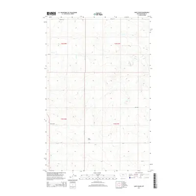
2014 Map of Gady Coulee
USGS Topo · Published 2014About this map
Gady Coulee cuts through this high-plains landscape of McCone County, Montana, where the terrain is defined by deeply etched drainage patterns and sparse human infrastructure. The map depicts a late-modern rural environment where travel is governed by long-distance routes like Mt-13 and Mt-201, which intersect in the southern half of the quadrangle. Water distribution is seasonal and focused around Sheep Cr, which meanders across the northern sections. This 2014 survey reveals a transition in land use, showing the grid-based township and range boundaries including t26n r48e and t26n r49e. Local access is provided by a network of gravel and improved roads such as Sunnyside Rd and Ahren Loop, tracing the natural contours of the coulee systems that dominate this section of the Big Dry country.
Find a feature on this map
13 named features on this map. Tap any name to fly to it.
Don’t see what you’re looking for? This feature index may not catch every label — zoom into the map to look around manually.
Map Details
Editions of this 2014 Gady Coulee Map
This is the sole edition of this map. No revisions or reprints were ever made.
Other maps of this area

1912 · Chelsea
USGS Topo · 1:62,500

1916 · Wolf Point
USGS Topo · 1:62,500

1954 · Glendive
USGS Topo · 1:250,000

1954 · Wolf Point
USGS Topo · 1:250,000

1957 · Glendive
USGS Topo · 1:250,000

1958 · Wolf Point
USGS Topo · 1:250,000

1958 · Glendive
USGS Topo · 1:250,000

1972 · Chelsea SW
USGS Topo · 1:24,000

1972 · Macon
USGS Topo · 1:24,000
1972 · Nickwall
USGS Topo · 1:24,000