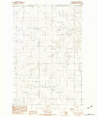
1983 Map of Gady Coulee
USGS Topo · Published 1983About this map
Sheep Creek meanders across the northern reaches of this eastern Montana landscape, reflecting the characteristic drainage patterns of the Missouri River plateau. Surveyed by the Geological Survey in the early 1980s, the terrain is defined by the winding course of Gady Coulee as it carves through the prairie. The map documents a sparsely populated agricultural and industrial environment, evidenced by scattered grain bins and an underground pipeline cutting across the eastern sections. This provisional survey provides a precise view of the topography and land use in McCone County during a period when modern energy and agricultural infrastructure began to leave a permanent mark on the open plains.
Find a feature on this map
4 named features on this map. Tap any name to fly to it.
Don’t see what you’re looking for? This feature index may not catch every label — zoom into the map to look around manually.
Map Details
Editions of this 1983 Gady Coulee Map
This is the sole edition of this map. No revisions or reprints were ever made.
Other maps of this area

1912 · Chelsea
USGS Topo · 1:62,500

1916 · Wolf Point
USGS Topo · 1:62,500

1954 · Glendive
USGS Topo · 1:250,000

1954 · Wolf Point
USGS Topo · 1:250,000

1957 · Glendive
USGS Topo · 1:250,000

1958 · Wolf Point
USGS Topo · 1:250,000

1958 · Glendive
USGS Topo · 1:250,000

1972 · Chelsea SW
USGS Topo · 1:24,000

1972 · Macon
USGS Topo · 1:24,000
1972 · Nickwall
USGS Topo · 1:24,000