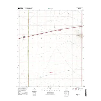
2013 Map of Gage NW
USGS Topo · Published 2013About this map
The high desert landscape where Grant Co meets Luna Co is defined by the stark rise of the Victorio Mountains in the northeast and the passage of Interstate 10. The settlement of Wilna sits along this major transportation corridor, which cuts across a terrain marked by ephemeral water features like China Draw. This 2013 survey illustrates the modern utility of the land through infrastructure like Pipeline Rd and the Pipeline Tank, which support water management and transport across the arid basin. Historically, the area represents a critical transit point for those moving through the southern New Mexico corridor between Deming and Lordsburg, where the vast, open spaces are navigated by a network of county routes such as Co Road C062 and Co Road D001.
Find a feature on this map
12 named features on this map. Tap any name to fly to it.
Don’t see what you’re looking for? This feature index may not catch every label — zoom into the map to look around manually.
Map Details
Editions of this 2013 Gage NW Map
This is the sole edition of this map. No revisions or reprints were ever made.
Other maps of this area

1954 · Silver City
USGS Topo · 1:250,000

1958 · Silver City
USGS Topo · 1:250,000

1962 · Silver City
USGS Topo · 1:250,000

1963 · Gage SW
USGS Topo · 1:24,000

1963 · Soldiers Farewell Hill
USGS Topo · 1:24,000

1963 · Gage NW
USGS Topo · 1:24,000

1963 · Gage
USGS Topo · 1:24,000
1963 · Grandmother Mountain West
USGS Topo · 1:24,000
1963 · Gage SE
USGS Topo · 1:24,000
1964 · The Saltys
USGS Topo · 1:24,000