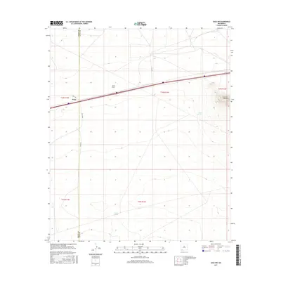
2017 Map of Gage NW
USGS Topo · Published 2017About this map
Wilna sits at a crossroads of ranching and transport history along the western edge of the Chihuahuan Desert landscape. This area, straddling the Grant Co Luna Co line, is defined by wide drainage patterns like China Draw and sparse but critical water sources including Briar Hill Tank and Pipeline Tank. The eastern boundary is dominated by the foothills of the Victorio Mountains, where the elevation rises sharply from the basin floor. Local transit follows a legacy of desert routes, with Quincy Rd and Wilna Rd SW providing access through the various township and range divisions. The map illustrates a high-desert environment where infrastructure is focused on managing distance and water, supporting a ranching economy that depends on these isolated points of utility.
Find a feature on this map
15 named features on this map. Tap any name to fly to it.
Don’t see what you’re looking for? This feature index may not catch every label — zoom into the map to look around manually.
Map Details
Editions of this 2017 Gage NW Map
This is the sole edition of this map. No revisions or reprints were ever made.
Other maps of this area

1954 · Silver City
USGS Topo · 1:250,000

1958 · Silver City
USGS Topo · 1:250,000

1962 · Silver City
USGS Topo · 1:250,000

1963 · Gage SW
USGS Topo · 1:24,000

1963 · Soldiers Farewell Hill
USGS Topo · 1:24,000

1963 · Gage NW
USGS Topo · 1:24,000

1963 · Gage
USGS Topo · 1:24,000
1963 · Grandmother Mountain West
USGS Topo · 1:24,000
1963 · Gage SE
USGS Topo · 1:24,000
1964 · The Saltys
USGS Topo · 1:24,000