1985 Map of Gainesville
USGS Topo · Published 1985About this map
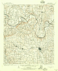
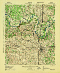
The Red River defines the winding border between Texas and Oklahoma in this mid-1980s landscape, serving as a geographic anchor for the numerous petroleum fields that dominate the region. Industrial footprints like the Nocona North Spanish Fort Oil Field, Muenster Oil Field, and Sivells Bend Oil Field are shown alongside established cattle and agricultural towns. The map captures a transition in transportation, marking an Old Railroad Grade near Nocona while several active lines, including the Burlington Northern and Oklahoma Kansas and Texas, converge on Gainesville. North of the city, the reach of Lake Texoma and the development of Moss Lake illustrate the importance of water management in this prairie environment. Educational and community landmarks such as Cooke County College and Lakeview Cemetery provide specific points of interest for those researching local family history.
Find a feature on this map
73 named features on this map. Tap any name to fly to it.
Don’t see what you’re looking for? This feature index may not catch every label — zoom into the map to look around manually.
Map Details
Editions of this 1985 Gainesville Map
This is the sole edition of this map. No revisions or reprints were ever made.
Historical Maps of Gainesville Through Time
4 maps found