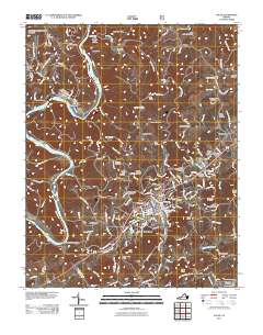
2011 Map of Galax
USGS Topo · Published 2011About this map
The New River carves a winding path through this region, anchoring settlements like Fries and Oldtown along its banks. The map highlights the industrial and transit heritage of the area, featuring the Fries Mill Dam and the New River State Park Trail, which follows an old rail corridor. Higher elevations are marked by numerous peaks including Toby Knob and Pilot Knob, overlooking a landscape densely populated with family and community burial grounds.
Find a feature on this map
71 named features on this map. Tap any name to fly to it.
Don’t see what you’re looking for? This feature index may not catch every label — zoom into the map to look around manually.
Map Details
Editions of this 2011 Galax Map
This is the sole edition of this map. No revisions or reprints were ever made.
Other maps of this area

1889 · Hillsville
USGS Topo · 1:125,000

1889 · Wytheville
USGS Topo · 1:125,000

1892 · Hillsville
USGS Topo · 1:125,000

1892 · Wytheville
USGS Topo · 1:125,000

1896 · Hillsville
USGS Topo · 1:125,000

1930 · Speedwell
USGS Topo · 1:62,500

1930 · Independence
USGS Topo · 1:48,000

1930 · Max Meadows
USGS Topo · 1:62,500

1931 · Galax
USGS Topo · 1:48,000

1933 · Independence
USGS Topo · 1:62,500