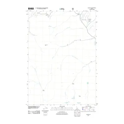
2011 Map of Galena
USGS Topo · Published 2011About this map
Galena stands at the northern edge of this high-elevation terrain, where the Big Wood River begins its course among the peaks of Blaine County. This 2011 survey documents a landscape defined by dramatic drainage systems and alpine basins, notably at Galena Summit and the nearby Galena Overlook. For those interested in the human history of this mountain settlement, the Galena Pioneer Cemetery remains a significant landmark near the confluence of Senate Creek and the river. The topography is punctuated by prominent summits including Bromaghin Peak and Norton Peak, with several high-altitude water bodies such as Mill Lake, Norton Lakes, and Prairie Lakes providing focal points for the surrounding canyons. A network of creeks, including Titus Creek, Owl Creek, and Coyote Creek, carves through the mountain passes, illustrating the complex watershed that feeds the region's major river systems.
Find a feature on this map
28 named features on this map. Tap any name to fly to it.
Don’t see what you’re looking for? This feature index may not catch every label — zoom into the map to look around manually.
Map Details
Editions of this 2011 Galena Map
This is the sole edition of this map. No revisions or reprints were ever made.
Other maps of this area

1900 · Sawtooth
USGS Topo · 1:125,000

1955 · Hailey
USGS Topo · 1:250,000

1959 · Hailey
USGS Topo · 1:250,000

1962 · Hailey
USGS Topo · 1:250,000

1963 · Alturas Lake
USGS Topo · 1:24,000

1964 · Frenchman Creek
USGS Topo · 1:24,000
1970 · Horton Peak
USGS Topo · 1:24,000

1970 · Paradise Peak
USGS Topo · 1:24,000
1970 · Galena Peak
USGS Topo · 1:24,000
1970 · Easley Hot Springs
USGS Topo · 1:24,000