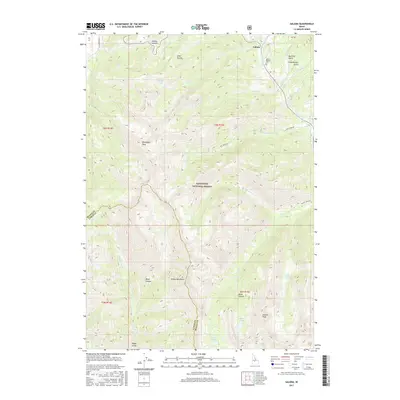
2017 Map of Galena
USGS Topo · Published 2017About this map
Galena sits at the northern edge of this high-elevation Idaho survey, serving as a gateway to the steep ridges of the Smoky Mountains. The landscape is dominated by the Sawtooth National Forest, where the headwaters of the Big Wood River are fed by numerous alpine basins. These basins contain remote water bodies including Norton Lakes, Miner Lake, Prairie Lakes, and Mill Lake. The area's human history is anchored by the Galena Pioneer Cem, which remains a silent witness to the early settlement near the Galena Summit. The map documents a complex vertical terrain of dramatic peaks and deep cuts, from Bromaghin Peak and Norton Peak to the narrow passage of Royal Gorge. This network of gulches and canyons, such as Enid Gulch and Miner Canyon, underscores the topographical isolation that defined travel and prospecting in this region of Blaine County.
Find a feature on this map
40 named features on this map. Tap any name to fly to it.
Don’t see what you’re looking for? This feature index may not catch every label — zoom into the map to look around manually.
Map Details
Editions of this 2017 Galena Map
This is the sole edition of this map. No revisions or reprints were ever made.
Other maps of this area

1900 · Sawtooth
USGS Topo · 1:125,000

1955 · Hailey
USGS Topo · 1:250,000

1959 · Hailey
USGS Topo · 1:250,000

1962 · Hailey
USGS Topo · 1:250,000

1963 · Alturas Lake
USGS Topo · 1:24,000

1964 · Frenchman Creek
USGS Topo · 1:24,000
1970 · Horton Peak
USGS Topo · 1:24,000

1970 · Paradise Peak
USGS Topo · 1:24,000
1970 · Galena Peak
USGS Topo · 1:24,000
1970 · Easley Hot Springs
USGS Topo · 1:24,000